What is a Watershed?
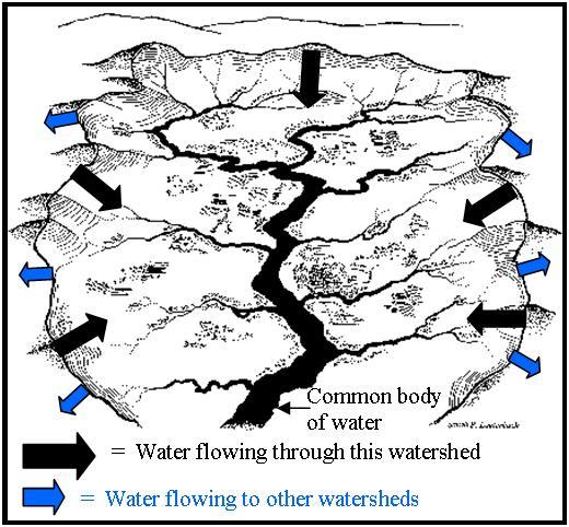
A watershed is a geographic area of land where all the water drains to a common body of water: a lake, pond, river or stream.
By definition a watershed can be any size. As an example, you could say the there are three watersheds in the continental United States: the Atlantic Ocean, the Pacific Ocean and the Great Basin. Everything east of the continental divide drains into the Atlantic Ocean, everything west of the divide flows into the Pacific Ocean. There is also a region of the mountain west where the water stays without draining directly by river to either sea known as the Great Basin.
Here in Monroe County we are all residents of the Delaware River watershed. Those of us living east of the Pocono Plateau drain directly to the Delaware via the Brodhead, Bushkill or Cherry Creeks. Those living on or South of the Plateau drain into the Lehigh River, on the way to the Delaware, via the Tobyhanna, Pohopoco and Aquashicola Creeks.
What is your watershed address?
In order to become stewards of our watersheds it is important to learn our watershed address. Your watershed address begins with the first named stream or lake that water flowing off your property will come to and ends with the Atlantic Ocean. For example, the watershed address of the Monroe County Conservation District offices is as follows:
Kettle Creek → Appenzell Creek → McMichaels Creek → Brodhead Creek → Delaware River → Delaware Bay → Atlantic Ocean
“Streams represent constant rebirth. The water flows in, forever new, yet for ever the same; they complete a journey from beginning to end, and then they embark on the journey again.”
- Tim Palmer
|
|

Technical Section
Monday through Friday: 8:00a.m. - 4:30p.m. Phone: (570)629-3060 • Fax: (570)629-3063 |
Environmental Education Center
Monday through Friday: 8:00a.m. - 4:30p.m. Some Saturdays 9a.m. - 1p.m. Phone: (570)629-3061 • Fax: (570)629-3063 |
8050 Running Valley Road
Stroudsburg, PA 18360
Stroudsburg, PA 18360
|
|
|

|
